Foto:
Lijiang Old Town
(Yunnan-provinsen i Kina)
Du er her:
»
FOTOBØGER »
SEVÆRDIGHEDER »
ASIEN »
KINA – YUNNAN
På denne side:
[ Kort | Fotobøger | Om Yunnan ]

Kort
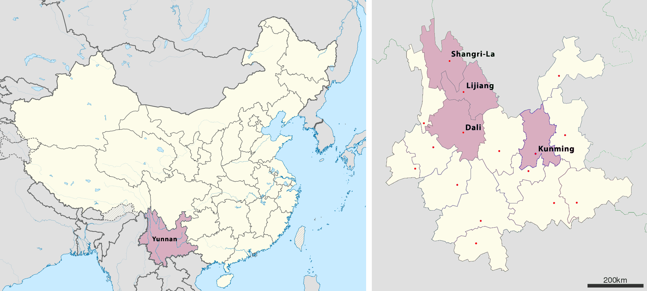
Det højre kort viser de områder, vi har besøgt i Yunnan.
IKKE VIST PÅ KORTET:
Stenskoven ligger 120 km øst for Kunming.
Dali Old Town ligger 10 km nord for Dali City, på vestsiden af Erhai Lake.
Xizhou and Zhoucheng ligger 20 km nord for Dali Old Town på vestsiden af Erhai Lake.
White Water River ligger 15 km nord for Lijiang Old Town, efter at have passeret Jade Dragon Snow Mountain.
Tigerspringskløften ligger midt imellem Lijiang og Shangri-La..
Fotobøger

Dali is one of the most popular spots for independent China travelers and hugely popular with those studying and working in southern China. About 50 min by plane or 4-5 hrs by bus from Kunming (Yunnan's capital), Dali is considered by some the perfect place to relax in southern China.
Dali is the seat of Dali Prefecture and includes Dali New City (下关, Xiàguān) and Dali Old Town (古城, Gǔchéng). The Old Town has a population of only 40,000 but the 10,000+ km² prefecture as a whole holds 3 million. When discussing or travelling to "Dali", it's important to be clear which you are talking about. Xiaguan is usually where transportation to "Dali" arrives but is a standard industrial Chinese city. Tourists are usually trying to get to the Old Town, which is famed for its traditional architecture, beautiful scenery (the dramatic Cangshan range, the expansive Erhai Lake, and small hand worked fields of pleasantly varied produce), minority cultures (mostly Bai but also Yi and Hui), and nightlife. There is also much to see and do in the surrounding countryside.
The climate is temperate with moderate summers and mild winters, though it can get rather windy in autumn and winter and the tropical latitude means some will need to bring extra sunblock.
Remember, as a tourist town in China, one will be charged higher prices for tourist goods whether Chinese or not. As a town in rural China, one will be charged higher prices just for being a foreigner. This includes everything ranging from market vegetables to legal fees and rent. This is true for both the Old town as well as Xiaguan. Go to places with prices on the menu, and if not, ask before buying.
Despite Dali's former fame as a backpacker heaven (in the late 90s and early 00s), foreigners are now hugely outnumbered by Chinese tourists, and has developed a reputation as the country's go-to for one-night stands. Dali has recently been overshadowed by nearby Lijiang and many group package tourists either bypass it or give it 1-2 days stay. Still, in contrast to Lijiang, Dali is not just an assembly of tourist souvenir stores, but people actually live and work there.
We spend two nights (one whole day) in Dali and it is a too short time. It is a very beautiful and nice place to stay, so it is worth to spend some more days here. Go and see the Erhai Lake Villages and the mountains.
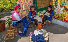
Tie-dyeing in Zhoucheng. Tie-dyeing originated from the central plains area in ancient China over 1,000 years ago. Being one of the locations of this craftsmanship, Zhoucheng Village near Butterfly Spring in Dali Old City is famous as the 'Hometown of Bai People's Tie-dyeing Art'.
Tie-dyeing is a technology of printing flower patterns on cloth. As the name suggests, the process is divided into "tie" and "dye". Tie refers to making the cloth into certain shapes by pinching, creasing and flanging it according to the flower patterns. They are then sewn or tie tightly together to make a bunch of knots. The aim of tying the knots is to dye the untied part while retaining the original color of the knotted parts. The tighter the knots are tied, the better the effect of the color printing will be achieved.
The dyeing process involves first soaking the 'knots' into clear water, followed by immersing them in the dye vat for a period of time before taking them out to dry. After drying, they are again put back in the dye vat and the process is repeated until a satisfactory color is achieved. Once dried, stitches are taken out of the knots and the cloth is smoothen out to reveal that part of the cloth which was sewn and form beautiful flower patterns and the dye crease marks.
The main colors of the tie-dying process are white and blue, with the white color for the flower patterns and the blue for the background. The contrast of these two colors shows the beauty of simplicity, which reflects the Bai People's peaceful and tolerant minds. The main dye comes from the Ban Lan Gen, the isatis root in English. Cloth dyed with this plant's extract is good to the skin and presents a color of bluish green that is not easily fade.
The tie-dyeing products in Zhoucheng Village are well sought after, both at home and abroad. Do drop by and witness for yourself the process of this historical craftsmanship. Who knows, you will return home with some cheap and beautiful crafted cloths.

Located in the middle of the Yunnan–Guizhou Plateau, Kunming is located at an altitude of 1,900 meters above sea level and at a latitude just north of the Tropic of Cancer. Kunming has as of 2014 a population of 6,626,000 with an urban population of 4,575,000 and is located at the northern edge of the large Lake Dian, surrounded by temples and lake-and-limestone hill landscapes.
Kunming consists of an old, previously walled city, a modern commercial district, residential and university areas. The city has an astronomical observatory, and its institutions of higher learning include Yunnan University, Yunnan Normal University and a medical college. On the outskirts is a famed bronze temple, dating from the Ming dynasty, and in the hinterland there is the Stone Forest.
Though having a nearly 2,400-year history, its modern prosperity dates only from 1910, when the railway from Hanoi was built. The city has continued to develop rapidly under China’s modernization efforts. Kunming’s streets have widened while office buildings and housing projects develop at a fast pace.
On 1 March 2014, 29 people died, and more than 130 were injured at Kunming Railway Station in what the Chinese Xinhua News Agency described as a terrorist attack. The attach happened only 6 weeks before we came to Kunming and the railway station was located only a few hundred meters from our hotel.

Location: Shilin Yi Nationality Autonomous County, 120 kilometers (75 miles) and 3 hours’ drive from Kunming.
Area: 400 sqare kilometers
Major Attractions: Greater & Lesser Stone Forests, Naigu Stone Forest, Zhiyun Cave, Long Lake, Moon Lake, Dadie Waterfall, Qifeng Cave, Guishan Mountain
Walking through the site, visitors marvel at the natural stone masterpieces and are bewitched by the intricate formations. The magnificent, strange and steep landscape creates countless labyrinthine vistas.
How was the Stone Forest in China Formed? Geologists say the Stone Forest is a typical example of karsts topography. Approximately 270 million years ago – during the carboniferous period of the Paleozoic era – the region was a vast expanse of sea. Over time, the movements of the lithosphere gradually caused a retreat of the waters and the rise of the limestone landscape. Due to constant erosion by the elements, the area finally developed into the present-day appearance.
Many beautiful legends originate in this magical place, passed along by the native people known as Sani, a branch of the Yi ethnic group. One particular story about the faithful love of Ashima, a beautiful, clever and warm-hearted Sani girl, is the most popular and has been told for thousands of years. The Sani people celebrate their national festival – the Torch Festival – every lunar year on June 24. They take part in traditional performances such as wrestling, bull fighting, pole-climbing, dragon-playing, lion-dancing and the A-xi Moon Dance. During this time, the place is alive with a particularly joyful, festive atmosphere, making the area even more attractive than usual. However, the Stone Forest - with its sculptures engraved by nature, herself - is always a true miracle for visitors to behold.

Owing to its low latitude and high elevation, the city centre of Lijiang experiences a mild subtropical highland climate (Köppen Cwb). Winters are mild and very dry and sunny (>70% possible sunshine), although average lows in December and January are just below the freezing mark; January, the coolest month, with 24-hour average temperature of 6.0 °C. Spring begins early and remains dry and sunny until late May, when there is a dramatic uptick in frequency and amount of rainfall that lasts until late September. Summers are warm, rainy (more so than it is sunny) and damp, with June, the warmest month, averaging 18.4 °C. Autumn sees an abrupt reduction in rainfall and return to sunniness. The annual mean temperature is 12.93 °C, while precipitation averages 980 mm, around 80% of which occurs from June to September. With monthly percent possible sunshine ranging from 32% in July to 80% in December, the city receives 2,463 hours of bright sunshine annually.
Old Town of Lijiang (丽江古镇) is a national historical and cultural city. It was built in the late Song Dynasty (late 13th century AD). It is located in the middle of Lijiang Dam. It is the most preserved and most Naxi-style ancient town in China. It is located in the Yunnan-Guizhou Plateau. At an altitude of 2,416 meters, the city covers an area of 3.8 square kilometers. In December 1997, it was included in the “World Cultural Heritage” list by the UNESCO World Heritage Committee.
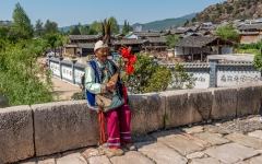
Baisha Village. If you want to witness the authentic life of the Naxi People and appreciate their culture but are tired of overcrowded Lijiang and Shuhe Ancient Town, then Baisha Village is the place to go. The village, at the foot of the Jade Dragon Snow Mountain, is about 8km to the north of Lijiang Old Town. It is much quieter because it is not commercialized. Here, you can experience the Naxi people's peaceful daily life.
Baisha Murals. Heading for this village, the Baisha Murals cannot be missed. These Murals are representative of Lijiang Murals and their creation took about three hundred years, from the early Ming Dynasty to the Qing Dynasty (1644 - 1911). The paintings were finished by Han, Tibetan and Naxi painters as well as painters from other nationalities, so they are not a symbol of Naxi Culture but a fusion of art from different nationalities. The peak of the Lijiang Murals was at end of the Ming Dynasty. Now only 55 pieces of murals are preserved in religious sites around Lijiang Town.
The Baisha Old Town was the political, commercial and cultural center for the local Naxi people and other ethnic groups for 400 years from the year 658 AD to 1107AD. The Dabaoji Palace of the Baisha Fresco, very close to the Baisha Naxi Hand-made Embroidery Institute, was built in the year 658 AD in the Tang Dynasty (618 AD to 907 AD).
Shuhe Old Town. Four kilometers (2 miles) to the northwest of the Lijiang Old Town, at the foot of Jade Dragon Snow Mountain, lies a compact village hidden in the forest, the Shuhe Ancient Town. UNESCO (United Nations Educational, Scientific and Cultural Organization) has listed it as an important component of Lijiang as it is a well-preserved example of a town along the ancient tea route and one of the earliest settlements of the ancestors of Naxi people. It is called 'the hometown of springs'.
The First Bend of the Yangtze River. Yangtze River, considerd the mother river of China, flows majestically through the center of China and is the third longest river in the world. Starting from the Qinghai-Tibet Plateau, the Yangtze River surges southeastward until it meets the Hengduan Mountain Range. About 71km outside of Lijiang, unusual geological phenomenons force the Yangtze to make a sudden V-shaped bend and flow to the northeast. This extraordinary turn, nearly 180-degrees, creates beautiful and marvelous views that startle the imagination. Here, the river is wide and the water flows in a gentle, slow pace. Large willow trees grow luxuriously alongside the river that is banked on both sides with lush, fertile deep green vegetation and immense, steep mountains that rise from the river to touch the clouds in the blue sky above. The whole sight is like a wonderful landscape painting that never ends. This is the First Bend of the Yangtze River - a world-famous geological phenomenon and an extraordinary panoramic scene whose vistas you will long remember with great pleasure.
Stone Drum. On the mountain at the river's bend stands Stone Drum (Shigu) Town, named after a drum-shaped marble plaque. Built during the Jiaqing era (1548-1561) of the Ming Dynasty (1368 - 1644), the stone drum is a monument commemorating the victory of Lijiang's Naxi ruler over an invading Tibetan army. It is one point five meters (five feet) in diameter and zero point five meters (two feet) in thickness. The stone drum has an obvious vestige of what appears to be a "rip" in it. It is said that the stone drum would rupture prior to any war and then fold when peace returned.
Throughout time, Stone Drum Town was always a significant and vitally strategic military area where many famous historical events have been taken place. It was here that Zhuge Liang, the famous and highly acclaimed military strategist of the Three Kingdoms Period, chose to cross the Yangtze River and gain "battle advantage" over his opponents. The first emperor of the Yuan Dynasty (1271 - 1368), Kublai Khan, used this place for his expeditionary forces to ferry across the river. In April 1936, the Second Route of the Red Army, led by General He Long and Ren bishi, crossed the river here and continued to march north. There are memorials here honoring the people whose histories are entwined with the Stone Drum Town.
This whole area abounds with attractive stories and dazzling visions. Stone Drum Town, together with the First Bend of the Yangtze River, and so many other spots nearby such as the Tiehong Bridge and Rock Gate ensure that a trip here will be an exciting one that you will greatly enjoy.
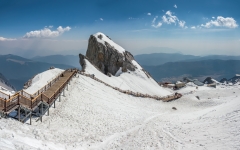
The Chinese name, Yulong Xueshan, translates directly as Jade Dragon Snow Mountain. The mountain's Naxi name is Mount Satseto.
The Jade Dragon Snow Mountain massif forms the bulk of the larger Yulong Mountains, that stretch further north. The northwestern flank of the massif forms one side of the Tiger Leaping Gorge (Hutiao Xia, 虎跳峡), which has a popular trekking route on the other side. In this gorge, the Jinsha (upper Yangtze) River descends dramatically between Jade Dragon and Haba Snow Mountain. The Yulong Mountains lie to the south of the Yun Range and are part of Southwest China's greater Hengduan Mountains.
Settlements surrounding Jade Dragon Snow Mountain include Baisha Town to the south, Longpan Township to the west, Daju Township to the northeast, and Jade Water Village at the foot of the mountain to the east.
The view of the massif from the gardens at the Black Dragon Pool (Heilong Tan) in Lijiang is noted as one of China's finest views. The mountain is part of Yulong Snow Mountain National Scenic Area and National Geological Park, an AAAAA-classified scenic area. The Park operates a tourist cable car that elevates to 4,680 m for close views of the snow peak, which is criticized for accelerating the melting of the snow and reducing the water retention by the mountain.
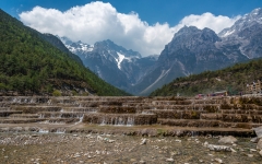
Blue Moon Valley is an extremely blue river meandering through a lush valley of Jade Dragon Snow Mountain. Seen from a distance, it resembles a blue crescent moon inlaid at the foot of the mountain. That's how the place got its beautiful name! However, blue is not the only color of the river. If it rains, the white mud and limestone rubble at the riverbed will be swirled up, making the water as white as milk. Therefore, local Naxi people name it White Water River (Baishui River).
The White Water River is fed by melting snow and ice running down from Jade Dragon Snow Mountain. The water is freezing; even in summer, and people still cannot bear the piercing cold when they dabble in the river. But it is a favorite iced drink in summer. Legend has it that, when two Naxi youngsters fall in love, the boy will be tested by standing barefoot in the cold river in winter to show his committed love for the girl. Folks believe that this tested love will last forever in the presence of the holy snow mountain. So, the river is considered the Love River in local people's mind.
There are four lakes divided by small waterfalls or giant rocks along the river, namely Jade-Like Wine Lake, Mirror Pond, Blue Moon Lake, and Wave-Listening Lake. The lakes form a natural mirror reflecting the grand snow mountain, surrounding cliffs, and lush plants. There are small shoals dotted among the water, breaking the smooth surface of the lakes. You can take good pictures anywhere along the river. But the best point is the White Water Terrace on the upstream. It is made up of fan-shaped stairs with the river running down from each step, looking like shining shells under the sunlight.
Shuttling between Spruce Plateau and the valley by ropeway, you can have a bird's-eye view of the deep and serene river valley, with the river as a jade girdle around the flourishing vegetation.
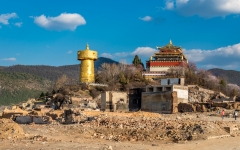
It was formerly called Zhongdian. Zhongdian was renamed Shangri-La for marketing reasons.
Population: 174,585, Area: 11,613 square kilometers, Nationalities: Tibetan, Han, Naxi, Yi, Altitude: 3,300 meters above sea level.
We visited Shangri-La in April 2014. A big part of the "old town" burnt down on January 11, 2014. It is in the process of being reconstructed. Many of the previous establishments in the old town have been relocated, rebuilt, or completely replaced.
Being the largest Tibetan Buddhist monastery in Yunnan, Songzanlin Monastery, also known as Guihua Monastery, is one of the famous monasteries in the Kang region. It is located near Shangri -La County, at the foot of Foping Mountain, five kilometers north of the county.
Construction of the monastery began in 1679 and was completed two years later. The monastery seems like a group of ancient castles and is composed of two lamaseries, Zhacang and Jikang. The gilded copper roof endows the monastery with strong Tibetan features and the 108 (an auspicious number in Buddhism) columns downstairs also feature the it with characteristics of Han nationality. The main halls in the monastery are magnificent, and on both the left and right sides are wonderful frescos, depicting Buddhist tales and legends. The inside-halls are exquisite with cloisters running through. The cloisters are all decorated with beautiful sculptures and consummate frescos.
The monastery is full of treasures. There are a lot of golden figures of Buddha josses, golden lamps, Tibetan lections, silver censers and so on. All of these are wonderful collections accumulated from each dynasty. They are precious productions made by people of both Tibet nationality and Han nationality.
Songzanlin Monastery has another alias - 'the little Potala Palace ', so named because the whole monastery is in the traditional style with mysterious atmosphere. In 1679, Dalailama chose this place by divination, and it went on to become the uppermost public place in Yunnan which features the particular local characteristics. Annually, the Gedong Festival is celebrated here by the Tibetans. Pious believers, with their knees and foreheads knocking the ground at every step, come here to pray.
The monastery is situated in the high-altitude region over 3,300 meters high. It snows even in August and has a rainy season that runs from June through September. Therefore, spring and summer are the best seasons for people to visit it.
About 22km southwest and 40 minutes’ drive from Shangri-la downtown area, Potatso National Park covers an area of 300 square kilometers and ranges from 3,500 yards to 4,160 meters high. It is renowned for well-preserved primitive landscape, which is endowed with lakes, wetlands, forests, meadows, streams, brooks, rare plants and animals. Meanwhile, Tibetan culture and custom are also component parts of the park.
As the first national park on the Chinese mainland, Potatso was open to visitors in 2007. In the park, there are three main scenic areas open to visitors: Bita Lake in the south, Shudu Lake which is a part of Three Parallel Rivers Scenic Area in the north and Militang Alpine Pasture in the middle. The sightseeing buses run among these scenic spots and stop at fixed stations. Passengers can get on and off freely with one ticket. As Bita Lake is a sacred place and Tibetan Buddhists walk around it clockwise for good luck, visitors are advised to sightsee clockwise too, in an order of Shudu Lake, Militang, and Bita Lake. Travel route in the park is about 69 kilometers and it takes about 4 – 6 hours to cover all the spots.
Shudu Lake and Bitahai Lake are two of the more accessible lakes in northeast of the city. Located within 10 kilometers of each other, legend says these "pearls of the land" are pieces of a mirror broken and scattered by a fairy while she was fixing her makeup.
As the highest lake in Yunnan Province, Bitahai Lake lies in the east of Shangri-La County of Diqing Tibetan Autonomous Prefecture. It is one of the core spots in Potatso National Park with an altitude over 3600 meters above sea level. Covering an area of about 159 hectares with an average depth of 20 meters, it is famous for its limpid water and its beautiful scenery which is set against the mountains and forests surrounding it.
Bitahai Lake is widely recognized as 'A Pearl on the Plateau' and the most attractive lake in Shangri-La. Legend has it that a goddess dropped her mirror carelessly to the earth when she was making up. The mirror was broken into pieces and they became lakes on the plateau. Among these pieces, the most beautiful piece with green jade turned into today's Bitahai Lake.
In the center of the lake stands an islet shaped like a boat sailing on the water surface. The islet is 30 meters above the water level and is covered with rare plants and also includes spruces and rhododendrons. Here, birds twitter happily, and flowers release their pleasant fragrances. When stepping on the islet, one feels as if they are arriving at Xanadu, and visitors have frequently remarked about how they have felt intoxicated by the aura, beauty and tranquility.
Bitahai Lake is fringed with rhododendrons of various varieties, which adds to its beauty. Every year around June and July, petals of the rhododendrons fall onto the water surface with the wind. When passing fish eat these rhododendron petals (which are slightly poisonous) they can be seen on their backs with their white bellies exposed as they float upside-down amongst the petals as if they are drunk. It is now the best-known sight of Bitahai Lake. It is also said that in the past bears in the nearby mountains often came out in the moonlight to catch these intoxicated fish.
Bitahai Lake is a place of legends. When visiting it, one can find that even a tree or a hill has a story. It is not only a feast to the eye, but also enhances our sense of beauty and our imagination.
Shudu Lake. It is about 20 minutes’ ride from the sightseeing bus stop near the park entrance. Reputed as a pearl in plateau, Shudu Lake is 3,700 meters above the sea level. The lake is crystal clear, with wild ducks paddling in group. There was a rare kind of fish species called Liefu Fish (fish with cracks on their bellies) living inside; but now visitors can barely see them due to damage to local eco-system. Along the shore, flocks of cattle and sheep wander freely. The lake is surrounded by rolling hills covered with forest. The primitive forest seems to be a verdant protective screen, where many rare animals inhabit, such as musk deer, bears, leopards, golden cats, tufted deer and eared pheasant.
Militang Alpine Pasture is the largest pasture in Potatso National Park, about 5 miles and 10 minutes’ drive from Shudu Lake. Under the azure sky dotted with clouds, the grassland is like a giant green carpet paved on the ground, with yaks and sheep scattered around and smoke from herdsmen’s chimneys drifting in the breeze. In spring and summer, a number of flowers are blossoming, which decorates the grassland into a colorful picture. In autumn, the land will be carpeted by spruce, azalea bosk, quercus, aquifolioides and redwoods. Wild mushrooms can be seen everywhere. It looks golden overall, tranquil and elegant. In winter, the land will turn into a tranquil white paradise.
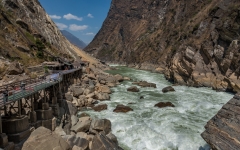
Naturally divided into three sections, the first section, which is the narrowest and uppermost section, is the mouth of the fast flowing Jingsha River. In the midst of the river's mouth is a large rock that is positioned at the gorge's narrowest section-only 30 meters (33 yards) wide. The altitude of the mouth of the Tiger Leaping Gorge is 1,800m.
An ancient legend says that a tiger used this rock as its stepping stone so it could leap across from one side of the gorge to the other, which is how the place got its name.
As the river enters the middle section, it drops another 100 meters (330 feet) and its flow rate increases to an amazing speed. Here the thunderous rushing waters slam into sharp, large rocks and crash down into the river forming swirling whirlpools. Can it get more exciting? Yes, it can as the third and lowest section is acclaimed for being the wildest attraction of all!
The cliffs over-looking this section are even steeper and much more dangerous. Here, the river twists and turns and the river vigorously surges forward creating high waves and a frothy spew as it collides with the mountainsides. This is a view that inspires a sense of adventure and satisfies the deepest yearnings for magnificent scenery.
The Tiger Leaping Gorge stretches about 15 kilometers (nine miles) and affords people the possibility of rafting and drifting peacefully in its large quiet sections, for the gentler folks among us and an exciting rafting adventure for the more experienced.
Om Yunnan
Yunnan (云南) er en provins i Folkerepublikken Kina og ligger i den sydvestlige del af landet. Den spænder over 394.000 km³ og har en befolkning på 45,7 mio. (2009). Provinsens hovedstad hedder Kunming. Provinsen grænser op til de kinesiske provinser Guangxi, Guizhou, Sichuan og den autonome provins Tibet samt landene Vietnam, Laos og Myanmar.
Yunnan ligger i et bjergrigt område, med de største højder i nordvest og laveste områder i sydøst. Størstedelen af befolkningen bor i den østlige del af provinsen. I vest kan højden variere fra bjergtoppene til floddaler med så meget som 3.000 meter.
Yunnan er rig på naturressourcer og har den største mangfoldighed af planteliv i Kina. Af de ca. 30.000 arter af planter i Kina har Yunnan nok 17.000 eller flere. Yunnan’s reserver af aluminium, bly, zink og tin er de største i Kina, og der er også store reserver af kobber og nikkel.
Yunnan har et generelt mildt klima med et behageligt vejr på grund af provinsens beliggenhed på sydvendte bjergskråninger, som påvirkes fra både Stillehavet og Det Indiske Ocean, og selvom vækstperioden er lang, så giver det ujævne terræn kun lidt dyrkbar jord. Under Köøppens klimaklassificering ligger meget af provinsen inden for det subtropiske højland (Köppen Cwb) eller i den fugtige subtropiske zone (Cwa) med milde til varme vintre og tempererede somre, undtagen i den næsten tropiske syd, hvor temperaturer regelmæssigt overstiger 30 ° C i den varmere halvdel af året. I almindelighed varierer januar gennemsnitlige temperaturer fra 8 til 17 ° C. Julis gennemsnit ligger mellem 21 og 27 ° C. Gennemsnitlig årlig nedbør varierer fra 600 til 2.300 millimeter, med mere end halvdelen af regnen mellem juni og august. Plateauområdet har moderate temperaturer. Den vestlige region med dybe flodsenge er varm ved dalbunden, men der er frysende vind på bjergtoppene.
Yunnan er kendt for sit meget høje niveau af etnisk mangfoldighed. Det har det højeste antal etniske grupper blandt provinserne og autonome regioner i Kina. Blandt landets 56 anerkendte etniske grupper findes 25 i Yunnan. Ca. 38 % af befolkningen er medlemmer af etniske minoriteter, herunder Yi, Bai, Hani, Tai, Dai, Miao, Lisu, Hui, Lahu, Wa, Nakhi, Yao, Tibetaner, Jingpo, Blang, Pumi, Nu, Achang , Jinuo, Mongoler, Derung, Manchus, Sui og Buyei.
Du er her:
»
FOTOBØGER »
SEVÆRDIGHEDER »
ASIEN »
KINA – YUNNAN